Guide to Fort Ogden, Florida
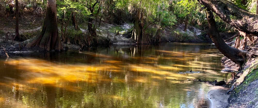
Peace River
West of Fort Ogden is the Peace River, a 106 mile long river that empties into the Mexican Gulf in Charlotte County, Florida.
Peace River is popular among canoers and kayakers, and parts of the river region is also famous for containing a lot of fossils. Several campgrounds and canoe rental operations are located along the river, in places such as Wachula, Zolfo Springs, and Arcadia. One of the tourist operations closet to Fort Ogden is the Seminole Wind Airboat Tours company, which offers guided tours in the beautiful natural environment created by the meandering Peace River. The business is adjacent to the Lettuce Lake Travel Resort and the Lettuce Lake Park, Kayak Launch & Boat Ramp.
Facts about the Peace River
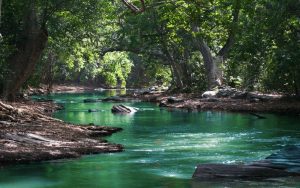
- The Peace River is a 106 mile (171 km) long river that runs through the southwestern part of the Florida penninsula and empties into the Mexican Gulf at the Charlotte Harbor estuary.
- This river originates where Saddle Creek meets Peace Creek, which is northeast of Bartow in Polk County. The drainage basin for the Peace River is 1,367 square miles (3,540 km2 ).
- Examples of settlments along the Peacer River are Fort Meade (in Polk County), Wauchula (in Hardee County), Zolfo Springs (in Hardee County), Fort Ogden (in DeSoto County), Arcadia (in DeSoto County), and Punta Gorda (in Charlotte County).
- U.S. Highway 17 runs near and somewhat parallel to Peace River for much of its course.
- The Creek and the Seminole name for the river is Talakchopcohatchee.
- Over six million gallons of water is taken from the Peace River each day to provide drinking water for the region.
Fossils
A lot of fossils from Pleistocene and Miocene have been found throughout the Peace River area, and parts of the northern watershed of the Peace River comprise the famous Bone Valley. The Peace River area, including Bone Valley, is a popular destination for fossil hunters, who dig and sift through the river gravel in hope of finding fossils such as fossilized mammal bones and shark teeth.
River crossings
- Spessard L Holland Bridge
- John Singletary Bridge
- Heard Bridge
- Doyle E. Carlton Bridge
- Barron Collier Bridge
- Albert W. Gilchrist Bridge
Charlotte Harbour Bridge: The first bridge over the Peace River in Charlotte County
The first bridge over the Peace River in Charlotte County was built in 1921 and named Charlotte Harbour Bridge. It was located just east of where we today find the Barron Collier Bridge, and ran from Live Oak Point on the northern bank to Nestbit Street in Punta Gorda.
In 1921, the Tamiami Trail (the southernmost part of U.S. Highway 41, from Tampa to Miami) had not been completed yet, but it was underway, and Charlotte Harbour Bridge was built in anticipation of it.
Once the Tamiami Trail had been completed in 1928, it soon became apparent that Charlotte Harbor Bridge was not enough to handle the traffic. In December 1929, work commenced on a new and better bridge – the first version of the Barron Collier Bridge, which opened for traffic on Independence Day 1931. Charlotte Harbour Bridge closed, the swing span over the navigation channel was removed, and the sides of the bridge were converted into fishing piers. (These piers are no longer present, as they were demolished in the late 1970s.)
Barron Collier Bridge
The Barron Cllier Bridge crosses the Peace River in Charlotte County, to connect Punta Gorda with Port Charlotte. It was named after Barron G. Collier, a prominent landowner in Southwest Florida.
The original Barron Collier bridge
The first version of the Barron Collier Bridge were built a block east of the Charlotte Harbor Bridge, at King Street, in 1929-1931, to replace the Charlotte Harbour Bridge. While Charlotte Harbor Bridge had a swin span, Barron Collier Bridge was designed as a low-level drawbridge.
One of the driving forces behind the creation of the new bridge was Barron G. Collier, who – among other things – owned the Hotel Charlotte Harbor at King Street.
To make room for the new bridge, the Atlantic Coast Line Railroad’s dock at King Street was demolished, and so was a passenger depot.
Barron Collier Bridge opened for traffic on Independence Day 1931.
The current Barron Collier Bridge
This is a 45 feet tall concrete girder bridge which carries the two northbound lanes of U.S. Route 41 (Tamiami Trail). The current Barron Collier Bridge was built in the early 1980s and is almost identical to Gilchrist Bridge.
It opened to traffic on January 12, 1983. Unlike the old Barron Collier Bridge, the current one is 45 feet tall which eliminates the need for a drawbridge.
The new bridge was built righ next to the old bridge, and when the new one had opened for traffic, the old one was demolished and sunk into Charlotte Harbor to form an artificial reef.
Albert W. Gilchrist Bridge
The 45-foot-tall Albert W. Gilchrist Bridge, commonly known simply as Gilchrist Bridge, carries the southbound lanes of U.S. Route 41 (Taiami Trail). The northbound lanes are carried by the adjacent Barron Collier Bridge.
The bridge is named after former Florida Governor Albert W. Gilchrist, who lived in Punta Gorda. It is considerably younger than the Barron Collier Bridge, and dit not open for traffic until Independence Day 1976 – exactly 45 years after Barron Collier Bridge.
The Gilchrist Bridge was created to make U.S. 41 a four-lane highway over the Peace River, and separating the northbound traffic from the southbound traffic. Gilchrist lands at Cross Street in Punta Gorda, several blocks west of Barron Collier´s landing at King Street.
Peace River
Ziba King
Arcadia
Food tourism